Deailed Maps of Greece
Location of Greece
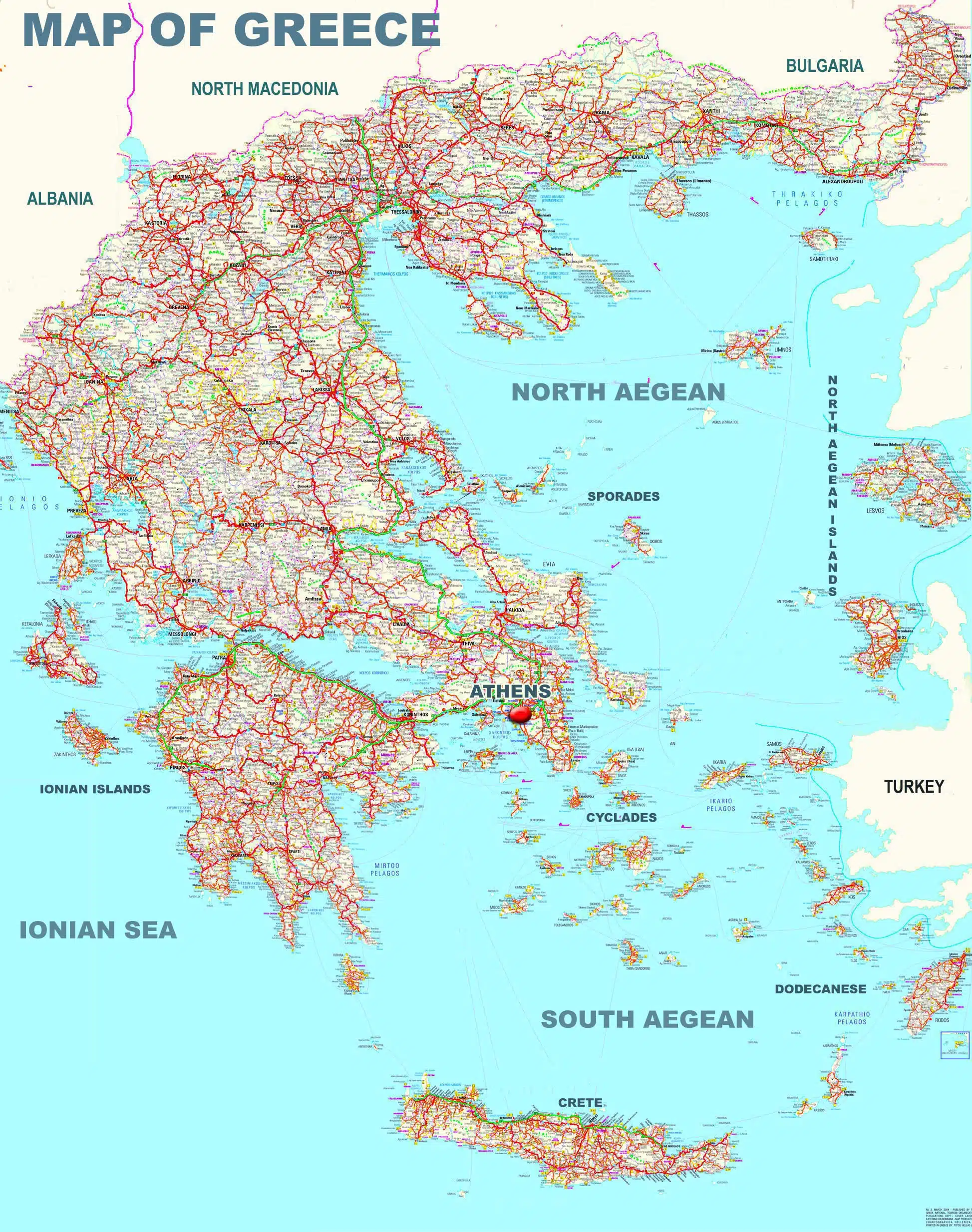
Greece located at the most southerly part of the Balkan peninsula as seen on the map and the south east of the Mediterranean sea. From the north Greece borders with Albania Nort Macedonia and Bulgaria. From the east it borders with the European part of Turkey. To the west of Greece is the Ionian Sea and to the east is the Aegean Sea. To the south is the Libyan Sea ,see more information about the Geography of Greece about the lakes, rivers and mountains of Greece ,details of the geomorphology of Greece you can find at the Physical map of Greece. The coast line of Greece is 13,676 km therefore having a the longer coastline in the Mediterranean. Most of the Greek islands and islets situated in the Aegean sea, while a small number of islands are in the Ionian Sea.
Greece in general is not dense inhabited, with a total surface of 132 000 sq.km, Greece has a population of about 11,000,000 inhabitants. The reason for that is that most of the Greek mainland is mountainous with a few plateaus in Thessaly, Macedonia and Thrace and a large part of the country consists of islands. Therefore most of the population of Greece is concentrated in the big urban centres with Athens and its greater area and Piraeus to have the one third of the Greek population followed by Thessaloniki , Patras, Heraklion and Larissa.
Climate
Surrounded by the Mediterranean sea in 3 parts Greece has as a result a mild climate with dry summers and mild winters. Greece’s strategic position between 3 continents Europe, Asia and Africa had as a result since the Antiquity to become an important cultural and commercial center.
Greece Map
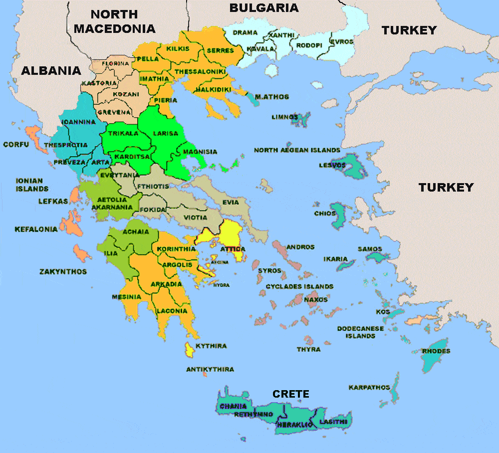
Greek regions map
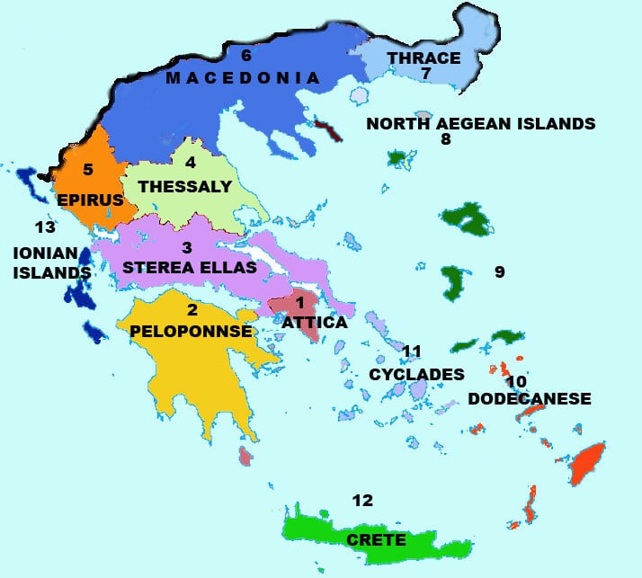
Greece is divided into 13 regions or peripheries. Macedonia (6) with Thrace (7) in the north and north west, Epirus (5) in the north west , Thesally (4 ) and Sterea Ellas with Evia (3) in the centre ,the Peloponesse (2) in the south, Attica (1). The Ionian islands in the west (13) , the Aegean islands (9) and the North Aegean islands (8) , Cyclades (11) ,Dodecanesse (10) , At the southern tip lies the largest island of Greece Crete (13)
Educational maps of Greece
Climate Map of Greece
This map aims to examine the varied climate characteristics of Greece and understand their impact on the natural environment and human life. Being a Mediterranean state, Greece is predominantly characterized by a Mediterranean climate. This climate features hot and dry summers, along with moderate to cold, rainy winters.
The coastal regions and islands of Greece enjoy a particularly mild climate, boasting many sunny days each year. This significantly contributes to the development of tourism in these areas. In contrast, the inland and mountainous regions experience more varied climatic conditions. Here, the continental climate prevails, marked by stronger seasonal changes. Winters are colder with snowfall being common, especially in the mountainous areas. Summers, while remaining hot, are often less dry than in the coastal areas.
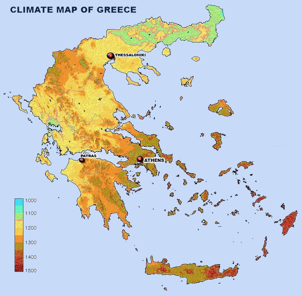
GREECE CLIMATE MAP
Satellite Map
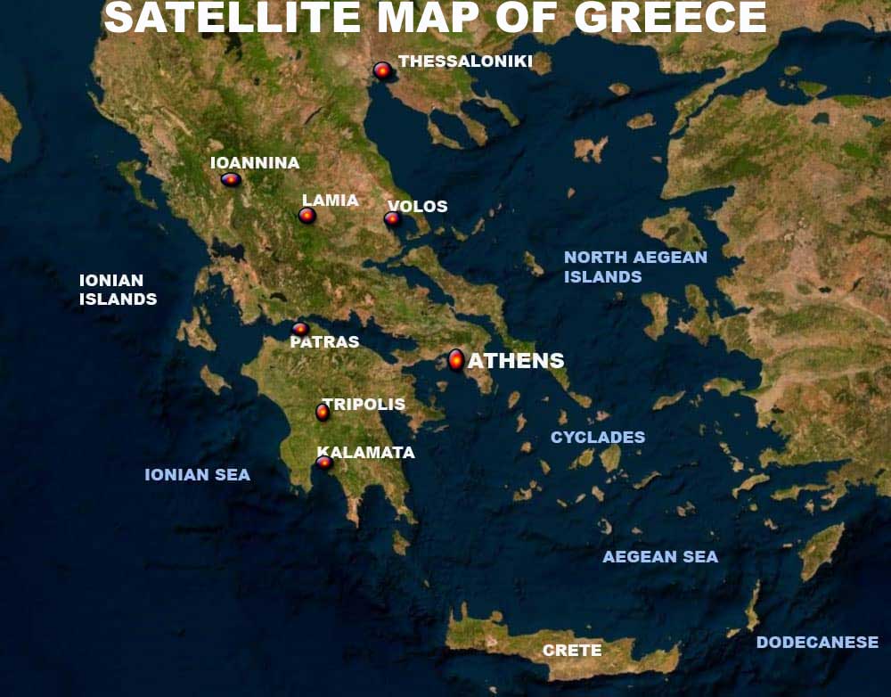
The satellite map of Greece presents an image of the country as captured by satellites in space. This image encompasses various aspects, including the geographical configuration, the distribution of towns and villages, transport networks, physical features, and other significant elements.
Greece is characterised by significant continental and insular diversity. The map vividly illustrates the large continental regions, such as Macedonia and the Peloponnese, along with the numerous islands scattered throughout the Aegean and Ionian Seas.
Prominent mountain ranges, such as Pindos and Rhodope, and extensive plains, like the Thessalian plain, are clearly distinguishable. Key rivers, including the Evros and Acheloos, and notable lakes, such as Prespa and Kerkini, are also visible. Major cities like Athens, Thessaloniki, and Heraklion, in addition to numerous smaller villages, can be identified.
GREEK PREFECTURES MAP
Greek islands map
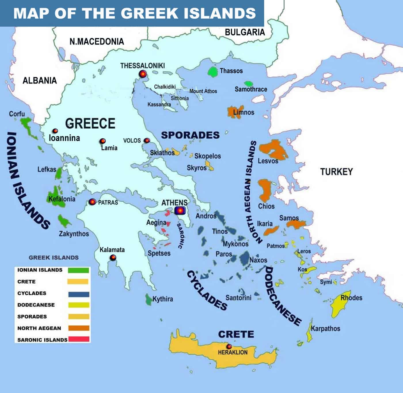
MAP OF THE ISLANDS OF GREECE
The Greek island groups of the Cyclades and the Dodecanese extend from Central Greece to the coasts of Asia Minor. The island arc formed by Kythera, Crete, Karpathos, and Rhodes connects the Peloponnese with the coasts of Asia Minor.
The islands of Greece are not merely a territorial extension of the country; they, along with the mainland, constitute a unified spiritual and cultural entity. This unity has been in existence since prehistoric times and has significantly contributed to the development of Greek culture and the formation of the Greek nation. Archaeological finds offer the most compelling evidence of this enduring connection.
In addition to the principal islands of Crete and Evia, the numerous Greek islands are categorized into eight main groups. These groups are as follows.
Sporades islands
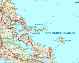 The Sporades islands located off the coast of mainland Greece and north east of the island of Evia, they are a still an unspoiled paradise characterised by a turquoise sea. They are distinguished in the north-west of the Aegean Sea. The archipelago of those islands located about 120 km north of Athens just off the east coast of Greece.
Among them the most important are the islands of Alonissos, Skiathos, Skopelos and Skyros. The topography of these islands is varied, with a mix of rocky landscapes, dense forests, and a number of beaches. The highest peak among these islands is found on Skyros, known as Mount Olympus (not to be confused with the famous Mount Olympus on the Greek mainland), which rises to an elevation of about 409 meters.
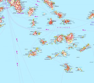 The Cyclades emerge from the blue of the Aegean with wonderful beaches and typical white and blue houses. The fascinating archipelago of the Cyclades consists of a group of islands of various sizes scattered in the blue waters of the Aegean Sea southeast of Attica.
These islands are primarily composed of rocky terrain and are known for their hilly landscapes, with the highest peak found on Naxos, Mount Zeus, reaching an elevation of approximately 1,004 meters.
Some of them are internationally known, such as Santorini, Mykonos, Paros, Syros, Ios and Naxos, while others remain less known and less touristy, but also beautiful such as Milos, Folegandros, Amorgos and others. The name of this group of islands comes from the Greek word Cycle and identifies the location of the islands around Delos, the sacred island of Apollo.
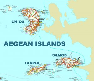 The East Aegean Islands include notable islands such as Lesbos, Chios, Samos, and Ikaria. These islands are characterized by diverse terrains including mountainous areas, hilly landscapes, and varied coastlines. Lesbos, for instance, has the region’s highest peak, Mount Lepetymnos, which reaches an elevation of about 968 meters. The islands are also known for their significant geological features, including hot springs and volcanic remnants.
The climate of the East Aegean Islands is predominantly Mediterranean, with mild, wet winters and hot, dry summers. This climate supports a wide variety of vegetation, from olive groves and vineyards to dense forests in certain areas. The geographical position of these islands also means they are subject to the meltemi, strong north winds that are particularly prevalent in the summer.
The East Aegean islands are: Thasos, Samos, Samotraki, Ikaria, Chios, Lesbos, Limnos, Agios Efstratios, Psara, Fourni, Oinouses. Demarcating the border between Greece and Turkey.
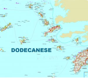 The Dodecanese islands located in the south east Aegean South of Samos up to the extreme limit of Greek territory the island of Kastelorizo. Among them from North to the South are the islands of Agathonisi, Patmos, Lipsi, Leros, Kalymnos, Kos, Nisyros, Symi, Rhodes, Kasos , Karpathos and Kastellorizo.
The Dodecanese comprise twelve major islands and numerous smaller ones, with Rhodes, Kos, Patmos, and Karpathos being among the larger and more well-known. The islands are characterized by their varied terrain, which includes mountainous regions, fertile valleys, and extensive coastlines. The highest point in the Dodecanese is Mount Attavyros on Rhodes, which reaches an elevation of approximately 1,215 meters.
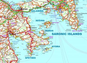 The Saronic Islands are a group of Greek islands located in the Saronic Gulf, close to the mainland of Greece. The main islands in the Saronic group include Aegina, Poros, Hydra, Spetses, and Salamis.
These islands are known for their varied landscapes, which include rocky terrain, small fertile plains, and a mix of sandy and pebbly beaches. The topography of these islands is generally hilly, with the highest point found on Aegina, known as Mount Oros, which reaches about 532 meters in elevation.
The economy of these islands is primarily driven by tourism, agriculture, and fishing. Islands like Hydra and Spetses are popular tourist destinations due to their proximity to Athens, offering visitors a blend of historical sites, natural beauty, and local culture. Salamis, the largest of the Saronic Islands, has a more diverse economy, including industrial activities alongside tourism and agriculture.
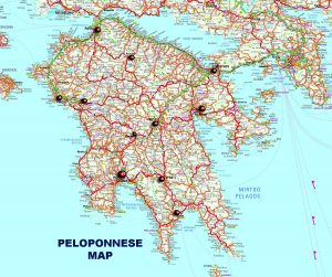 Peloponnese is a peninsula in the southern part of Greece. It is bordered to the north by Corinth, to the east by the Aegean Sea and the Aegean Sea, and to the south and west by the Ionian Gulf Important cities in the Peloponnese include Patras, Kalamata, Tripoli, Corinth, Sparta and Nafplio, among others.
Peloponnese offers a variety of natural beauties, such as beautiful beaches, mountains, gorges and of course many historic places like Olympia, Mycenae and Sparta. Peloponnese has deep historical roots and is associated with ancient Greece, the Spartan culture, the struggle for Greek independence from the Ottoman Empire and many other historical events.
Physical Map of Greece
