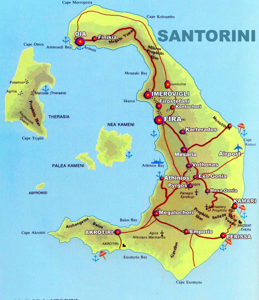
Map and geography of Santorini
Santorini, also known as Thera, is a Greek island located in the southern Aegean Sea. It is part of the Cyclades group of islands and lies approximately 120 miles (200 kilometers) southeast of mainland Greece. Here are some key points about the geography on the map of Santorini:
-
Formation: Santorini is a volcanic island that was formed by a series of volcanic eruptions over thousands of years. The island’s geological history is marked by several major eruptions, with the most significant occurring around 3,600 years ago, which resulted in the collapse of the central part of the island and the formation of a large caldera (a volcanic crater).
-
Caldera: The caldera of Santorini is one of its most distinctive features. It is a roughly circular, water-filled depression that measures about 7.5 miles (12 kilometers) in diameter and is surrounded by steep cliffs that rise up to 1,000 feet (300 meters) above the sea level.
-
Islands: The Santorini group of islands comprises several smaller islands within the caldera. The largest among them are Thira (also known as Santorini), Thirassia, and Aspronisi. Nea Kameni and Palea Kameni are two volcanic islets located in the center of the caldera, and they are still considered active volcanoes.
-
Villages: The main settlements of Santorini are perched on the cliffs overlooking the caldera, offering breathtaking views. The most famous villages include Fira (the capital), Oia, Imerovigli, and Firostefani. These villages are characterized by their traditional white-washed houses, narrow winding streets, and blue-domed churches.
-
Beaches: Santorini’s beaches are known for their unique volcanic landscapes. The island’s volcanic past has left its mark on the coastline, with beaches featuring black, red, and white volcanic sand or pebbles. Some popular beaches include Perissa, Kamari, Red Beach (near Akrotiri), and White Beach.
-
Landscape: The landscape of Santorini is defined by its rugged cliffs, volcanic rock formations, and picturesque vineyards. The island’s volcanic soil is fertile, supporting the growth of vineyards that produce the renowned Santorini wines. The terraced vineyards, known as “pezoules,” are a characteristic feature of the island’s agricultural landscape.
-
Neighboring Islands: Santorini is surrounded by other beautiful islands in the Cyclades archipelago. Some notable neighboring islands include Ios, Naxos, Paros, and Mykonos. These islands are accessible by ferry, and island hopping is a popular activity among visitors to the region.
Overall, Santorini’s geography is characterized by its volcanic origins, the dramatic caldera, stunning cliffside villages, and unique beaches, all of which contribute to its status as a world-famous tourist destination.