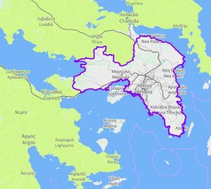
Prefecture of Attica
The Prefecture of Attica occupies the South East end of Central Greece. It also includes the Saronic islands, the region of Trizinia and the islands of Hydra, Spetses, Kythira and Antikythira. Mainly borders NW with the Prefecture of Boeotia, NE is bathed by the Evian Gulf, North by the Saronic Gulf and West by the Corinthian Gulf. It has an area of 3,808 sq. Km. And a population of 3,522,769 inhabitants. The capital of the prefecture is Athens. Administratively it is divided into six provinces: Attica with Athens as its capital, Megaridos with Megara as its capital, Kythera with Kythira as its capital, Trizinias with Poros as its capital and Hydra with Hydra as its capital.
HISTORY OF ATTICA
 Attica has been one of the most important regions of Greece since antiquity. It was first inhabited in the Neolithic Age. Its first king was Kekropas, who created its first 12 municipalities.
Its center was the Acropolis. Great personalities acted there. In the 5th BC. ai. the municipalities reached 100, while its cultural development reached the top.
The city of Athens became a powerful state, thanks to the founding of the First Athenian Alliance. Even after its defeat in the Peloponnesian War, the region continues to prosper. The domination of the Macedonians and the Roman period did not stop this course.
After the 3rd c. received many barbaric raids. In Byzantine times it was on the sidelines of events, while during the Turkish occupation it suffered irreparable damage.
It was liberated in 1833 and integrated into the Greek state. During this period Athens was chosen as the capital of Greece.
GEOGRAPHY OF ATTICA
Soil
Most of the land of South Attica is semi-mountainous. Analytically, its distribution in categories is as follows: 26% plain, 65% semi-mountainous and 9% mountainous.
Mountains
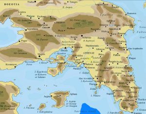
The mountains of Attica are Kithaironas located in the W of the prefecture, Pateras located N of Kithaironas, the Geraneia Mountains that extend from W to A in the province of Megarida, Parnitha, Penteli, Ymittos, the Mountains of Keratea, the Montenegro and the Hills of Kythera.
Plains
The plains of Attica are not large. The main ones are located in Menidi, Liossia, Varybobi, Agios Stefanos, Megara, Elefsina, Mediterranean, Marathon and Oropos.
Rivers
Today there are no rivers in the prefecture. Exceptions are Asopos, which rarely leaks its soil and Ilissos, which originates from Hymettus and flows into Faliriko Bay. In ancient times there was the water-rich Kifissos, which originates from Parnitha. Today Kifissos has water only in winter, during a period of rainfall.
Lakes
There is only one lake in the prefecture, Lake Marathon, which is the large water reservoir for Athens.
Thermal Springs
There are three thermal springs in the Prefecture of Attica. The Source of Souvala in Aegina, the Source of Vouliagmeni in the homonymous community and the Springs of Methana on the shores of the Peloponnese.
Forests
Attica has a large forest cover. Main forest trees are pine and fir. Most of the forests are located in the provinces of Attica and Megaridos. Climate Attica has a dry climate, with the main characteristics of mild winters and hot summers.
ECONOMY
The economy of the prefecture is heavily influenced by the area of the capital, which is a huge market. The cities around it are large industrial centers. Nevertheless, a large part of the population is engaged in agriculture. Agricultural crops include cereals, legumes, industrial and livestock plants, potatoes, nurseries and vineyards. Poultry, beekeeping and cow breeding are also developed. The prefecture also shows great commercial traffic, because Athens has an increased population. Let us also not forget that the port of Piraeus is the largest import and export port in the country.