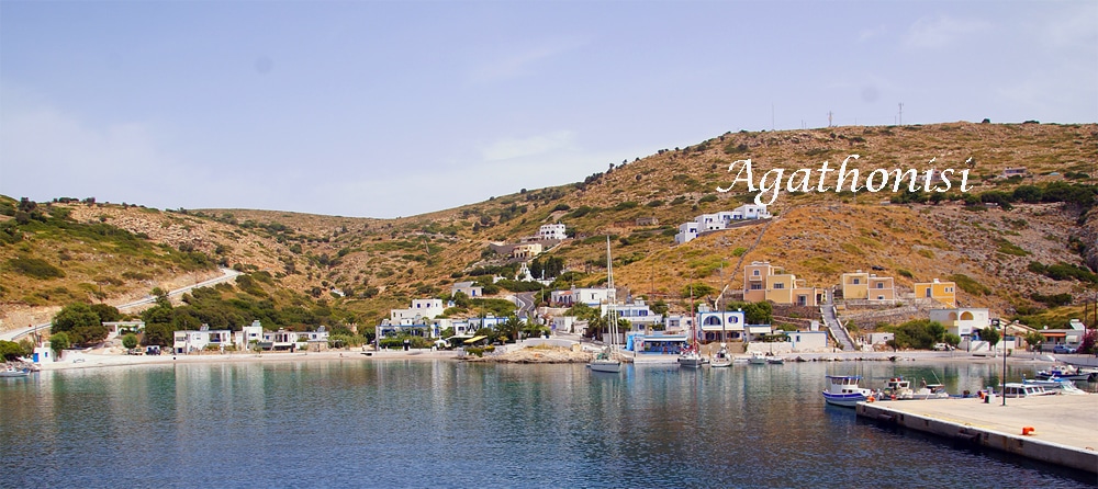
Agathonisi island Dodecanese
 Agathonisi is the northernmost island of the Dodecanese, with sheltered bays, lacy coasts and many small rocky islets. Its natural beauties contrast with the wild rocky nature, with no trees but plenty of bushes, giving it a purely personal and special character.
It is a small, untouched paradise, with pristine landscapes, with clean and untouched beaches, with picturesque settlements and picturesque alleys and unique churches.
Here everything is authentic and exudes a unique calmness and harmony. Agathonisi preserves the traditional island way of life and defends its ecological character. The residents are particularly friendly and cordial, they will remind you what Greek hospitality means. Picturesque tavernas by the sea, waiting to offer plenty of seafood, but also local products.
Agathonisi has its own history, attractions and archaeological findings, its customs and traditions, its traditions and festivals. It does not have a large church, but it has several beautiful and picturesque churches, scattered throughout the island.
It is surrounded by pristine and beautiful beaches, most of which are accessible by footpath or by boat and are not organized. Most beaches are sheltered from the wind, have pebbles and some tamarisk trees for natural shade.
 Agathonisi has three settlements that are only a short distance from each other and stand out for their traditional island architecture and lovely gardens, cobbled squares and narrow streets that are ideal for nice walks.
It is a place ideal for carefree and calm holidays, with relaxed rhythms, for endless dives, for true communication with its hospitable inhabitants, far from worldly tourism.
Agathonisi is a piece of dry land, in the middle of the Aegean, the remnants of life that spans centuries, a small earthly paradise where solitude is synonymous with freedom.
It is the laughter of the few children in the narrow streets that are mixed with the sounds from the bells of the two-aisled churches that host the prayers and food of the few residents.
Geography
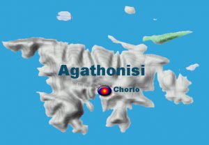
The terrain of the island consists of rocky and barren hills with many few plains. Cultivable land is scarce. The vegetation is poor and bushy, sparse and the trees, olives, carobs, almonds, figs and prickly pears. There are no springs except a few brackish water wells. The residents’ water supply is provided by rainwater tanks, which are filled by water-carrying ships in periods of no rain.
Agathonisi is surrounded by six rocky islets: Glaro or Katsagani to the east, Kuneli or Kounelonisi to the south, Nera or Neronisi, Pita or Piato or Psathonisi or Psatho, Praso to the north and Strogyli or Strogylos and several unnamed islets or islets with which they form the Polynisos of Agathonisi.
Agathonisi in antiquity is referred to as Yetoussa (island with many waters), Thucydides calls it Tragaia island, Strabo calls it Tragaiai nisosi, Plutarch Tragia and Stefanos Byzantinos Tragaiai. However, its current name, according to the most likely version, means island with thorns (Agathonissi) and it is referred to by travelers as Agatonissi.
Its current name, which has been used for the last fifty years or so, and the text of the renaming of the island was signed by all the residents. After all, they themselves decided the name of their place at the beginning of the 20th century. to apparently avoid the less sonorous Ga(i)daros or Gaidouronisi (probably because of its shape) and Agathonisi.
Nature
Agathonisi, together with the neighboring islands, is part of the NATURA 2000 protected area and is a habitat for rare species of birds, such as the Herring Gull, the seal Monachus monachus, the sea turtle Caretta caretta. The endemic plant Silene holzmannii also thrives on the island, which is protected by the Berne Treaty and the Greek Legislation, while on most of the rocky islands around Agathonisi there are some species that are disappearing, such as: Convolvulus oleifolius, Helichrysum orientale, Allium commutatum, Lavatera arborea.
The terrain of the island consists of rocky and barren hills with many few plains. Cultivable land is scarce.
The vegetation is poor and bushy, sparse and the trees, olives, carobs, almonds, figs and prickly pears. There are no springs except a few brackish water wells. Its main port is Agios Georgios and the port of Katholikos is a small natural port, the second largest in Agathonisi, where most of the island’s fishermen anchor and operate.
Agathonisi is surrounded by six rocky islets: Glaro or Katsagani to the east, Kuneli or Kounelonisi to the south, Nera or Neronisi, Pita or Piato or Psathonisi or Psatho, Praso to the north and Strogyli or Strogylos and several unnamed islets or islets with which they form the Polynisos of Agathonisi.
History
Agathonisi belonged to the so-called Melisian islands which were from the 4th BC. century military garrisons of the Ionian metropolis of Miletus. According to Thucydides, the first inhabitants of Tragaia (Agathonisi) were the Kares, who lived on the western coast of Asia Minor and Samos. Tragaea is mentioned as the hometown of the philosopher Theogitos, a student of Aristotle. During historical times it was inhabited by Dorians who were expelled in turn by the Ionians of Miletus.
Due to its geographical location, the inhabitants witnessed many naval battles such as the naval battle of Ladis in 494 BC. between the Persian fleet of Darius and the rebellious Ionians aided by Aeolians, who decided the fate of the opposite Miletus. With the victory of the Persians, the Ionian revolution (499-494 BC) ended and the ground began to be prepared for the Persian invasion of Greece.
In 440 BC near the island Pericles fought a battle with the Samian fleet. In 74 BC, as Plutarch tells us, the Roman emperor Julius Caesar, sailing from Italy to Asia Minor, was caught by pirates of Tragaia and taken to the islet of Farmakonisi, where he was kept. During the Byzantine period, it was probably settled by Byzantine exiles, like many other small islands of the Aegean, to whom the current language idiom of its inhabitants, a particularly pure Greek dialect, is probably due.
The island was settled and abandoned several times by its inhabitants, due to unfavorable conditions. Thus, Agathonisi experienced several phases of absolute abandonment. Characteristic is the description of the well-known Ottoman admiral and geographer Piri Reis as an uninhabited place on which only goats grazed.
In 1087 the island came under the jurisdiction of Patmos when Saint Christodoulos became the owner of the islands and built the Monastery of Patmos and in 1292 Agathonisi as well as other estates and islets, was donated with an imperial bullion to the Holy Monastery of Patmos. In 1310 the Dodecanese passed into the hands of the John Knights. Until the 14th century, because the island was not always inhabited continuously, it was a hideout for pirates and, along with the rest of the Dodecanese, it met many conquerors.
In 1522, together with the other Dodecanese, it came under the rule of the Turks, Sultan Suleiman II (the so-called Magnificent), who granted a special privileged status to the islands and remained until 1912.
After the revolution of 1821 and despite the expectations of their inhabitants, the Dodecanese remained outside the borders of the Greek state. On August 6, 1824, the defeated Turkish-Egyptian fleet took refuge here. On August 29, 1824, the naval battle of Gerontas took place in the east of the island. In 1909, the Young Turks abolished the privileges enjoyed by the Dodecanese.
In the middle of the 19th century, cattle breeders and fishermen from Patmos and Fournos settled and established a permanent settlement. Then its oldest settlement, Megalo Chorio, was built, invisible from the sea, while the stone wall around the houses that apparently served as a defensive fortification can still be seen today.
In 1912 Italy, which was at war with Turkey over Cyrenaica, occupied the islands to force the Turks to retreat. The Italians initially spoke of autonomy and self-government, creating the illusion of immediate liberation for their Greek residents (131,332 out of a total of 143,482, in 1912). But this did not happen and Italy kept the islands. In 1943 the Germans occupied the island for a short time. On March 7, 1948, it was definitively incorporated into the Greek state.
Economy
The economy in Agathonisi is based mainly on fishing, livestock farming and in recent years on tourism. The island is rich in catches where there are two fish farming units, in Vathy Pigadi and in the sheltered bay of Katholikos, which also employ several of its permanent residents. In the livestock sector, sheep and goats are raised with free grazing and excellent livestock and dairy products are produced, which, in addition to local consumption needs, are also exported to the surrounding islands. In recent years with the development of tourism, a small tourist infrastructure has been created and small units of rooms for rent have been erected.
The permanent population of the island is 186 inhabitants according to the census of 2021. After the summer when the tourist season ends and the visitors leave the island, life is different. The population is decreasing, the rhythms are falling, the living conditions are different and sometimes harsh.
Customs and culture
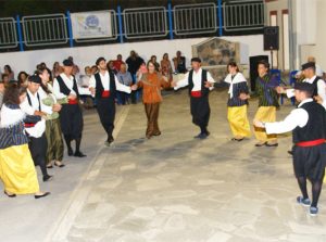
Residents light bonfires in the squares and jump over them to cleanse themselves of evil spirits.
Christmas and Holy Week are celebrated with traditional splendor. At Easter, the lamb is served not on the spit, but stuffed with rice in the oven.
The people of the island are revelers, that’s why the festivals are famous for the fun, music and dancing that last until the morning. The fame has spread to the surrounding islands, Samos, Patmos, Leipsos and Leros, resulting in people coming to the island to feast authentically. In Agathonisi there are scattered chapels, where various festivals are held, mainly in the summer months.
Local cuisine
Agathonisi is famous for its fresh fish and seafood, stews and cheeses. In the taverns of the island you will try, lemon or stuffed lamb, lamb in the oven with potatoes, braised goat with potatoes, steamed clams, fresh myzithra cheese, locally traditional dishes (sweets with honey).
Traditional fava beans or fliskoukudi, taco cheese (salty cheese ideal for wine and ouzo), fava beans, lobster, octopus in wine and fish soup
Villages in Agathonisi
Agios Georgios
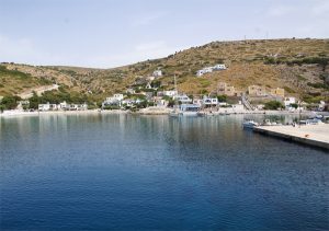
Around the harbor are spread out the few whitewashed houses with flat roofs and blue windows. The small settlement with its few permanent residents, which has been developing quite a bit in recent years, is bustling with life in the summer months. This is where most of the island’s accommodation, tavernas and cafes are located, as well as the central pebbly beach which is one of the busiest.
Katholiko
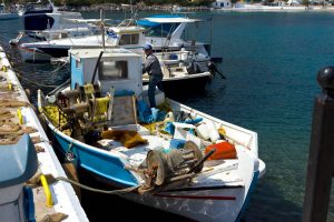
Between the port and the adjacent island of Nera, a fish farm operates, exporting around 500 tons of fish each year and providing vital jobs to the island’s residents. In Katholiko there is also a small tavern, where you can enjoy delicious seafood dishes. In the Gulf of Katholikos there is also the legend of the island.
Years ago while a ship was traveling to Samos it was wrecked and a woman with her child drowned. The residents buried them in an abandoned lime kiln without a priest reading them. Since then it has been rumored that a woman comes out at night and screams. Testimonies of locals cannot explain the glow emitted by the lime kiln on some very dark and moonless nights.
Megalo Chorio
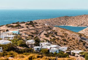
The village, which stands out for its architecture, has a stone wall around the houses with large entrance doors and narrow streets for nice walks. The older buildings present an interesting architectural quirk with rectangular, single-story, single-chambered houses with thatched roofs and patella, built of dry stone and internally plastered with red clay.
The village is full of narrow streets and alleys ideal for nice walks. Its small paved square, at some point, is covered with a mosaic depicting the island and the surrounding rocky islets of Agathonisi. In the square there is a small cafe, a steakhouse and a tavern with cooked food. Of interest are the small churches of Zoodochos Pigi, Agios Ioannis the Theologian and the chapel of Agios Raphael with their common partition and curved roof. In the wider area we find the chapels: Agioi Anargyroi, Agioi Ioannis tou Prodromou, Agia Irini Chrysovalantou and high on the top of Mount Kefala, Agios Charalambos.
Mikro Chorio
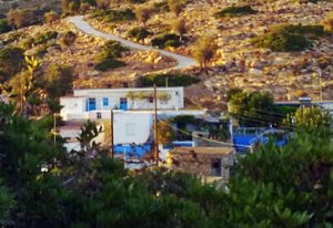
The settlement with its narrow little streets is ideal for walks. At the top of the hill and at a distance of 100 meters from the village, there is the small chapel of Agios Panteleimon, with a wonderful view of the area, which celebrates on July 27, with a large number of people from the surrounding islands. The elegant two-story church of Theologos and Panagia and next to it the small chapel of Agios Raphael poses on the street.
What to do
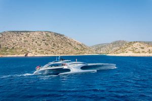
It is ideal for exploring the rich seabed. The round of the island is quite interesting, with many well-formed bays and very safe anchorages along the coastline and with the surrounding islets to the north, east and south.
In recent years, with the development of tourism, a small tourist infrastructure has been created with small units of rooms for rent, few taverns-restaurants with good food and fresh seafood.
Beaches
The beaches of Agathonisi are not just about sun and sea; they are also gateways to experiencing the island’s rich natural beauty and traditional charm.
The island’s small size and limited infrastructure mean that the beaches remain largely unspoiled, providing a stark contrast to more commercialized tourist destinations. This allows visitors to immerse themselves in the authentic ambiance of the island, where the pace of life is slow and the beauty of nature is the main attraction.
Agathonisi’s beaches offer a unique combination of natural beauty, tranquility, and authenticity. Whether it’s the sandy shores of Tsangari Beach, the rugged beauty of Gaidouravlako, the secluded charm of Poros, or the convenient location of Spilia, each beach provides a different facet of the island’s appeal. The pristine waters, scenic landscapes, and peaceful atmosphere make Agathonisi’s beaches perfect for those seeking a true escape in the Aegean.
What to see in Agathonisi
In Agathonisi, several archaeological investigations were followed from time to time by the Archaeological Service, in the decades of the 1980s and 1990s. The systematic topographic survey and subsequent investigation of the antiquities was started by dr. Pavlos Triantafyllidis archaeologist in 2001 with the help of Agathonisios. During these investigations, older and new archaeological sites were identified, which date from the prehistoric to the proto-Byzantine period.
Specifically, the sites of Kefala and Kalivia date back to the late 3rd millennium BC, in historical times the sites of Karlamboukia, Alonia, Agios Konstantinos, Kleftos, Mikro Damaki or Damakia, Benetou, Prezivolia and Kavi (Hellenistic-Roman period) and in the early Christian – early Byzantine times the sites of Tsaggaris, Agios Ioannis and Tholoi.
Among the monuments of historical times, the open-air Hellenistic sanctuary of the eastern deities in Kavi, in the south-eastern part of the island, is of special interest, with engraved footprints and dedicatory inscriptions in the natural uncut rock of the area.
North of the settlement of Megalo Chorio, on the southern and eastern slopes of the mountain Kleftos – a toponym that indicates the hasty hiding of treasures – visible scattered remains of architectural members from building remains, which are probably related to the ancient settlement of Tragaia, were found.
Tragaia
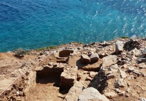
15,000 hives have been found and old pine cocci have been detected, which means that the island at that time was full of pine and thyme. Now only the thyme is left. Honey was also used as a stabilizing element in the dyeing of fabrics with purple. The purpura comes from the bug that is in a spiny shell. Porphyries still abound in that area today.
The dyehouse consists of two tanks on two levels, which communicated with each other with the overflow system. The close relationship of the island’s inhabitants with Miletus is also proven by the discovery of a significant number of copper and silver coins minted by Miletus and the Carian dynasty of the Hecatomnids of the 4th century BC.
Clay figurines of the Tanagraia type, from the late 4th century BC, textile weights, sealed amphora handles (Rhodian and Cnidian type), large quantities of ceramics and iron ores have also been found. But the most interesting of the findings is a sealed clay tile with the first official inscription of Agathonisi, from the late 2nd and early 1st century BC, referring to a military victory of the Milesian metropolis for the sake of which the mock sanctuary was founded, probably of Zeus , in the fortified coastal settlement of the island. The settlement was abandoned in the first half of the 2nd century AD, after an earthquake (155/156 AD) that shook Asia Minor and caused irreparable damage to the fort.
The Domes
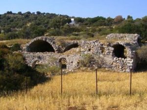
The building has a rectangular shape and consists of seven ground-floor vaulted spaces, with entrances to the east and south and stone-built or pebbled floors. In most of the vaulted ceilings, clay ventilation ducts are preserved, as in the partition walls, many of which have beams for the support of a wooden floor or loft.
In the southwest corner of the third dome there is an inscription and a Christogram inscribed in a circle. The form of the building, unique in the Aegean area, parallels similar building complexes of large warehouses in Asia Minor, which were found not only in cities and ports, but also on nodal road arteries.
After all, the strategic geographical position of Agathonisi on the sea route from the central Aegean and the Dodecanese to the ports and large cities of Asia Minor, such as Miletus, was not accidental for the choice of the installation of the warehouses, since they would serve, in addition to commercial and military purposes, such as the security of sea transport during the Arab raids in the 7th century, as well as the smooth supply of the empire’s versatile Byzantine fleet.
It is assumed that they were used apart from the Byzantine navy later by the Holy Monastery of Agios Ioannis the Theologians of Patmos. Today, although the building is neglected, its roof is still standing and the area is surrounded by wire for security reasons.
Kastraki
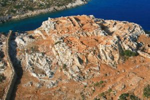
It all started in 2000, when the archaeologist Pavlos Triantafyllidis, of the KB Ephorate of Prehistoric and Classical Antiquities of Rhodes, was invited to go to Agathonisi to check the site where a desalination unit was to be installed. With the assistance of the Local Government and private sponsorships, a systematic excavation began in 2006, where the findings were impressive. A port from the Hellenistic period (late 4th – early 3rd century BC) has been found in Maistro’s bay, surrounded by strong fortification walls (1.80 – 2.00 m thick).
The ancient port was manned militarily from Miletus. It was a naval base of Miletus, as Agathonisi, Leros, Leipsoi and Patmos were the so-called Milesian islands. That is, the islands that Miletos used as a passage to the Aegean. Excavations have been identified in the rock associated with the docking facilities of the maneuvers
Caves
The caves that are numerous in Agathonisi. The best known are the cave of Agios Nikolaos whose entrance is located near the chapel of Agios Nikolaos, on the road to the Catholic Church and near the Domes. It is a large chasm that communicates with the two ends of the island through underground galleries.
There are five caves hidden around the island, which the inhabitants used as shelters from the threat of pirates. The best known is Chrysospilia with stalagmites and stalactites located on the beach of Spilia.
Getting around
Public transportation is virtually non-existent on Agathonisi, reflecting the island’s low population and minimal tourist development. This lack of formal transport infrastructure contributes to the island’s peaceful ambiance, allowing visitors to enjoy a slower pace of life.
The absence of buses and busy roads means that the natural sounds of the sea and the rustling of leaves dominate, creating a tranquil environment ideal for relaxation and reflection.
The island’s compact size, spanning just 14.4 square kilometers, means that transportation options are limited and simple, aligning perfectly with its unspoiled and laid-back atmosphere.
The primary mode of moving around Agathonisi is on foot. The island’s small dimensions and well-marked paths make walking the most practical and enjoyable way to explore. Visitors can easily navigate between the main settlements of Megalo Chorio and Mikro Chorio, taking in the picturesque views of white-washed houses, narrow winding streets, and stunning vistas of the Aegean Sea.
Walking not only offers a chance to appreciate the island’s natural beauty and traditional architecture but also allows for spontaneous encounters with the friendly locals, enhancing the overall experience.
For those looking to explore further afield or reach some of the more remote beaches and coves, renting a bicycle or scooter can be a convenient option. Bicycles are a popular choice due to the island’s relatively gentle terrain and short distances. They provide a faster means of transport while still allowing for an intimate connection with the surroundings.
Scooters offer a bit more speed and convenience, particularly for visitors who want to visit multiple sites in a day or carry beach gear with them. Rentals are generally available in the main harbor area, and it’s advisable to check with local accommodations or tavernas for recommendations.
The island also features a few local taxis, which can be arranged for longer trips or for those who prefer not to walk or cycle. These taxis are usually available near the harbor or can be booked through local establishments. While not as commonly used as walking or biking, taxis offer a comfortable and hassle-free way to reach more distant locations or to travel with luggage.
How to get to Agathonisi
You can ge to Agathonisi either by conventional liner, or by high-speed boats, depending on the time, the day of the crossing and the port of departure. The journey takes approximately 6:30 to 8:30 hours by high-speed ferry and 8 to 11 hours by regular ferry, depending on the route and ferry company.
Agathonisi is connected to Kalymnos, Leipsos, Leros, Patmos and Pythagorion of Samos, daily with regular routes and intermediate stations.
With fewer routes it also connects to Arkioi, Astypalaia, Kos, Rhodes and Symi with intermediate stations. A modern heliport operates on the island.
The sheltered and quiet bay of Agios Georgios offers the possibility of mooring private boats.
