Geography of Andros island Greece
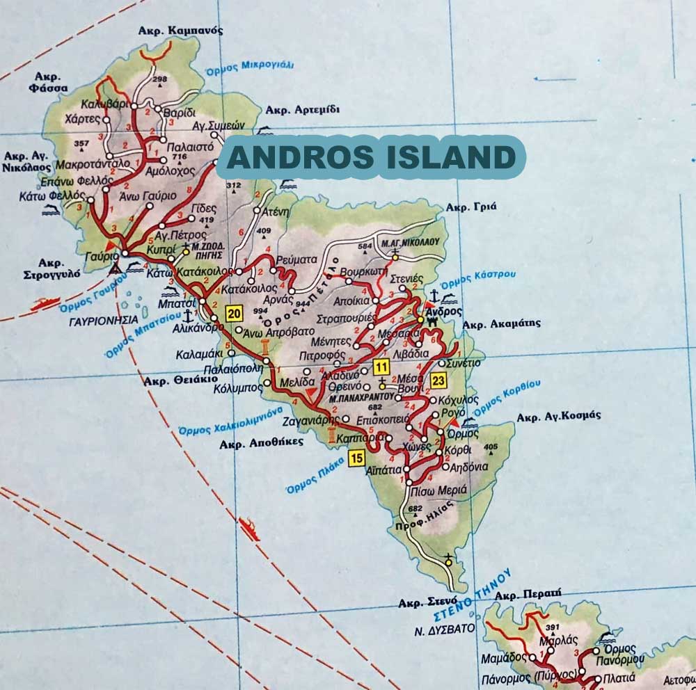
Andros is one of the most mountainous Cycladic islands with a richly indented, mostly sheer coast. Four almost parallel mountain ranges each run from southwest to northeast.
In between there are gorges and valleys with streams that sometimes carry water all year round and lush vegetation. Beaches exist almost exclusively in the estuaries of streams, and beach walls often form.
Andros with 383,022 square kilometers is the second largest Cycladic island after Naxos. Andros is separated from the western Aegean island of Euboea by the approximately 11 km wide and 400 m deep Kafireas Strait.
Location
The Greek mainland coast of Attica is about 56 km to the west. From the southern tip of Cape Steno, the distance to the nearest Cycladic island of Tinos is 1.5 km. In the immediate vicinity of the north and east side are some uninhabited small rocky islands.
The Gavrionisia are located in the Bay of Gavrio on the south side. Farthest away, but belonging to Andros, are the Kalogeri rocks some 42 km north-east in the middle of the Aegean Sea.
In the northwest-southeast direction, Andros stretches over 39.8 km. At its widest point in the center of the island, from Cape Thiaki on the west coast to Cape Gria on the east coast, the island is 16.7 km. The narrowest point is in the south of the island from the west coast to the Bay of Korthi at 5.3 km.
Mountains
To the north, the Agii Saranda mountain reach 718 m. The island’s highest peaks are in the central Kouvara-Petalo mountain region. The northern ridge of Kouvara has several peaks of almost the same height, the Profitis Ilias at 997 m is the highest elevation. Petalo is only connected to the Kouvara on the north-west side and also reaches heights of over 990 m. The 28.2 km² catchment area of the Megalos Potamos lies in the valley of Chora.
Rivers
The 11.6 km longest river on the island flows into the Paraporti beach south of the island’s capital Andros.Further south are the mountain ranges of Gerakones 685 m) and Tsirovlidi ( 726 m) and in the extreme south of the Rachi with a lenghth 682 m.