
Exploring the Dramatic Landscape :The Unique Geography of Santorini
The island of Santorini, officially known as Thira, is essentially what remains after an enormous volcanic eruption that occurred around 1600 BCE. This catastrophic event is believed to have led to the collapse of the Minoan civilization on the nearby island of Crete, due to a massive tsunami.
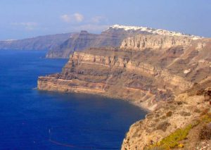
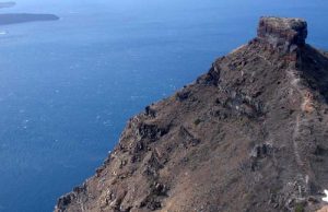
The eruption created the caldera, a vast crater that is now filled with seawater, making it one of the world’s most significant volcanic features. The caldera is surrounded by steep cliffs on three sides, with the island’s main towns perched atop these cliffs, offering stunning views of the deep blue waters below.
 Santorini’s landscape is marked by its volcanic soil, which imparts a distinct character to its agriculture. The island is renowned for its wine production, particularly the Assyrtiko white grape variety that thrives in the porous volcanic earth, allowing Santorini to produce some of the most prized wines in the Mediterranean. The soil also supports the growth of unique produce, such as cherry tomatoes, fava beans, and capers, which feature prominently in local cuisine.
The island is an archipelago that includes Thira, Thirasia, Aspronisi, Palea Kameni, and Nea Kameni, with the latter two being formed due to later volcanic activity. Nea Kameni, still an active volcanic center, is a popular tourist spot where visitors can hike to the crater to witness sulfur vents and hot springs, showcasing the island’s ongoing geological activity.
Santorini’s beaches are another highlight of its geography, with the eastern and southeastern coasts offering stretches of black and red sand beaches, such as Kamari, Perissa, and the famous Red Beach near Akrotiri. These unusual colors are a direct result of the volcanic minerals in the sand, providing a stark and beautiful contrast to the crystal-clear waters of the Aegean Sea.
 Despite its arid climate, with hot summers and mild winters, Santorini’s ingenious inhabitants have historically adapted to their environment through the development of unique agricultural practices. The iconic image of vineyards in Santorini involves vines trained into basket shapes, or “kouloures,” to protect them from the strong winds and intense sun, a testament to the islanders’ resilience and creativity in facing the challenges of their environment.
The geography of Santorini, with its dramatic cliffs, stunning caldera views, unique beaches, and fertile volcanic soil, not only shapes the physical beauty of the island but also deeply influences its culture, cuisine, and way of life. This interplay between nature and human activity has created a destination that is not just visually breathtaking but also rich in history and tradition, making Santorini a truly unique jewel of the Aegean.
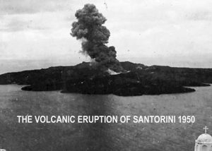
The Volcanic eruption of 1950
 The volcanic eruptions of Santorini in the 1950s are a reminder of the island’s dynamic and evolving landscape, shaped by the powerful forces of nature. While these eruptions were relatively minor compared to the ancient Minoan eruption, they play a crucial role in understanding the volcanic history and future potential of this iconic Aegean island. The beauty of Santorini today, with its dramatic caldera and unique geological formations, is a direct result of its volcanic past, attracting visitors from around the world to marvel at its natural wonders.
The volcanic activity during this period is part of the ongoing volcanic evolution of the Santorini caldera. The eruptions that took place primarily in 1950 were characterized by explosive events and the effusion of lava flows. The activity was concentrated on the island of Nea Kameni, which has been the site of repeated eruptions over the past few centuries, gradually increasing the size of the island with new lava deposits.
Impact and Observations
The eruptions were closely monitored by scientists, providing valuable data on the behavior of caldera-forming volcanoes. Although the 1950s eruptions did not cause significant destruction or fatalities, they did prompt evacuations and caused concern among the island’s residents. The volcanic activity produced ash falls, pyroclastic flows, and impressive lava fountains, creating a spectacle that was observed and photographed by both locals and visitors.
One of the notable aspects of the 1950s eruption was the formation of a new lava dome and the addition of new land to the island of Nea Kameni. These geological changes offered researchers insight into the processes of dome formation and the dynamics of volcanic eruptions in a caldera setting.
Scientific Significance
The 1950s eruptions in Santorini have been studied in the context of the broader volcanic history of the area. Santorini’s caldera is the result of multiple volcanic eruptions over thousands of years, with the Minoan eruption being the most famous and devastating. The more recent activity provides scientists with clues about the ongoing volcanic processes beneath the island and the potential for future eruptions.
Volcanologists continue to monitor the Santorini volcano closely, using data from past eruptions, including those in the 1950s, to predict future activity. The Santorini caldera is part of the Hellenic Volcanic Arc and is considered an active volcano with the potential to erupt again. Monitoring efforts include seismic activity measurements, gas emissions analysis, and ground deformation studies to ensure the safety of the island’s residents and the many tourists who visit Santorini each year.